

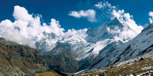
Have you ever considered walk thinking about the height you will cover instead of the distance? You may never have done it, nothing happens. We had not seen a walk either – or trekking, which seems to be much nicer to use the word in English – as ascension. We left that for climbers. But all this changes when you are in a country of climbers and when the hike is between mountains of 8,000 meters high. We talk about Nepal and the Annapurnas region. Would you be able to walk a kilometer vertically from 2,700 meters above sea level to 3,700 in one day?
Reach Jomson, the Capital of the Mustang
When you fly to a small city in a remote area, such as the Mustang in Nepal, you realize that there are many types of airports. Jomson has because, despite being small, it is the capital of the district. The plane that connects Pokhara airport with Jomson airport looks like a bus. Not only because of the size, but because it reaches the runway, it approaches the terminal, opens the door for passengers to get off while they take out the luggage – neither, because there is also no space on the plane, you leave everything in Pokhara and carry only the basics – and, without the pilots leaving or moving the plane, the next batch of travelers enters.
Read More: Top 8 Amazing Tour Places For Mountain Walking Tours
Inside the plane, the surprise is even greater when you see that the seatback has to be lifted and secured with your body or that there is no cockpit beyond a curtain that is open almost all the time. But, when the hostess – yes, there is one – passes offering candies and cotton … cotton? Before I give you time to think about what you want cotton, the propellers turn on and the thunderous noise inside the plane makes it clear what cotton is for your ears.
After a journey between mountains, because we do not believe that this plane was able to pass over them, remember that we talk about the highest mountains in the world, you arrive at Jomson airport. Almost as similar to any other airport that you have seen as the place where you arrive at any other one on which you have ridden. When we returned, we discovered that the metal detector arc was a kind of tester with curtains in which passengers were frisked one by one. At least, that was the theory, because the hands of the guards moved little from their pockets.
The Mustang is one of the most unreachable places in Nepal. Okay, you’ll be thinking, if they arrived by plane … I mean the tall Mustang, the old kingdom of Mustang near the border with Tibet. Getting it is not available to anyone without preparation, training, equipment … so, we walk down the lower Mustang, in the Annapurnas region.
This Is Jomson
Before leaving the airport, you must pass the first check. You need a permit to walk through this area – or it was when we were – and a policeman sitting at a desk points the data around the world. It would not be the last control: in the tourist office, they keep a part of the permit and, before leaving Jomson, you have to go through the police station to re-register. Although you think you have to go to many places, Jomson is a small town with a main “street” where the tourist office, the police station, and all the hotels, hostels, lodges and restaurants are located.
It seemed simple until I discovered that on the permission of The Trekkers’ Society someone had decided that my year of birth was 1930 … and of course, that got a bit of attention. Eternal youth or typical error? Evidently, it was typical error. But it could also be that someone else’s permission was straining them, which was not the case.
Our plan was to reach the Muktinath temple in a couple of days … have we ever fulfilled a plan?
Walking In the Annapurna
What landscape do you expect to find almost 3,000 meters high in the Himalayas? We did not have a definite idea: snow, cold, wind … Only the wind was fulfilled. The sun began to itch almost since we left Jomson and followed the bed, practically dry at that time, of the Kali Gandaki River, the old route used to exchange goods between Tibet and India. Today still widely used by refugees from Tibet who escape to Nepal?
The thing looked good, the wind kept us cool and the sunscreen and the cap did their job with the sun. Thus, in about two hours, we arrived at a village where we rested and ate something less than half an hour from Kagbeni, where we would have had to spend the night to continue the next day. Already? Two and a half hours of walking? We thought the same … we were elated – maybe the purity of oxygen at that point had something to do – and it seemed like a waste of time to stop before noon.
What would you have done? We ask the guide if we could reach Muktinath in one day. His answer left us out of place: “I can.” We knew that, but what we were asking was if we could…
“Adventure is an adventure and here we have come to walk.” Something like that we should say to convince ourselves The case is that, when the road forked, on the left the river and Kagbeni and on the right the mountains and Muktinath, we turn to the right. Not before stopping at a restaurant to eat, because the guide told us that it was four hours -optimist? – walking and there was nothing between that point and the town of Ranipauwa, next to the temple.
The Vertical Kilometer Adventure Begins
The concept of vertical kilometer exists as a regulated sports discipline and, in addition to the obvious height gain; the distance traveled cannot be greater than 5 kilometers. Okay, we walk more, about 18 or 20, but it was our vertical kilometer.
As we climbed, the wind also increased. A basic tip: long pants and a long-sleeved T-shirt if you don’t want the sand that lifts the wind to end your skin. Because this is a desert, rocky, but desert.
A few hours later, we didn’t have them all with us about arriving in Muktinath. We were beginning to suffer, more Sara – who does not learn with the walks -. When we saw a town appear in the distance,